Ottoman Empire size in 1590 compared with the Roman Empire and Turkey
At its peak in 1590, the Ottoman Empire covered about 4.66 million km² (1.8 million square miles), measured on the outline from the Cliopatria database together with its vassal states: the Crimean Khanate, Wallachia, Moldavia and Transylvania. That is 6.0 times present-day Türkiye and 1.4 times India, on three continents. Yet it was smaller than the Roman Empire at its height: it had 88% of its area. On a Mercator map, Greenland looks 5.0 times bigger than the empire, although the empire was 2.2 times bigger.
Ottoman Empire map: from Osman's beylik in 1326 to Türkiye in 2020
Move the year slider to see how a small beylik in Anatolia grew into a state on three continents. Switch the projection to compare it with the rest of the world on a flat map and on the globe. Green marks the vassal states from 1520 to 1700, which paid the sultan tribute but kept rulers of their own: the Crimean Khanate, Wallachia, Moldavia and Transylvania.
1590 4.66 million km², the largest extent
- Ottoman Empire4.32 million km²
- Vassal states350,000 km²
- Brown lines: present-day borders
Boundaries: Cliopatria (Seshat Global History Databank), licensed CC BY 4.0, modified: fitted to the coastline and simplified. Coastline and present-day borders: Natural Earth. Historical extents are approximate. Cliopatria · CC BY 4.0
Ottoman Empire on Mercator and Equal Earth maps
The Mercator projection enlarges regions more the farther they lie from the equator. Both maps below use the explorer's scale and show the world from 60°S to 84°N. Red is the empire in 1590; purple is Greenland.
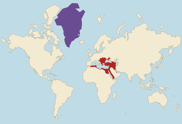
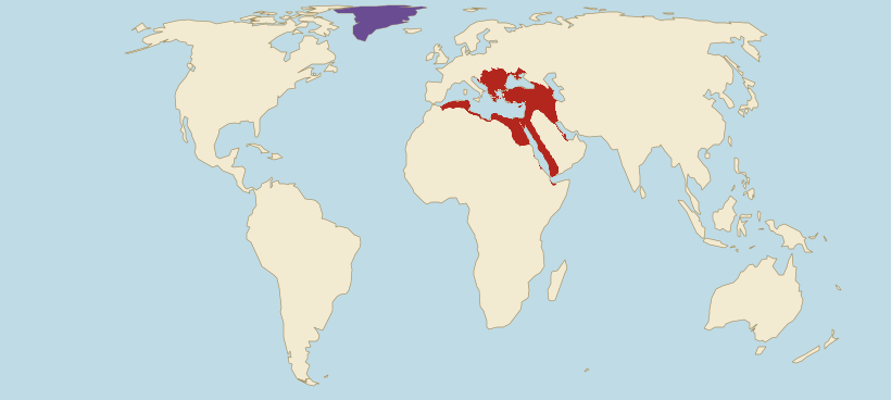
- Ottoman Empire with its vassals (1590)
- Greenland
Borders: Cliopatria (Seshat Global History Databank), licensed CC BY 4.0, modified. Land: Natural Earth.
- On Mercator, the empire looks only 1.2 times bigger than present-day Kazakhstan, although it was really 1.7 times bigger, because Kazakhstan lies farther north.
- On Mercator, the empire looks like just 7% of the Russian Empire of 1866, although it really had 21% of its area.
- Mercator does not even enlarge the empire evenly. Compared with land on the equator, the part of the empire in present-day Hungary grows on this map 2.1 times on average and the part in Yemen 1.07 times, so the first grows 2.0 times as much.
Ottoman Empire vs Roman Empire: guess, then check
At its peak, was the Ottoman Empire bigger than the Roman Empire?
Ottoman Empire size next to today's countries
The empire's area in 1590, its vassal states included, compared with selected countries, using the site's verified figures. The second line shows how the same comparison looks on a Mercator map.
- TürkiyeArea: 780,000 km²The empire was 6.0 times larger.On Mercator it looks 5.5 times larger.
- United StatesArea: 9.83 million km²The empire had 47% of this area.On Mercator it looks like 32% of this area.
- IndiaArea: 3.29 million km²The empire was 1.4 times larger.On Mercator it looks 1.8 times larger.
- KazakhstanArea: 2.72 million km²The empire was 1.7 times larger.On Mercator it looks 1.2 times larger.
- EgyptArea: 1 million km²The empire was 4.7 times larger.On Mercator it looks 5.7 times larger.
- Saudi ArabiaArea: 2.21 million km²The empire was 2.1 times larger.On Mercator it looks 2.7 times larger.
Present-day countries inside the Ottoman Empire of 1590
We measure on the drawn outline with the vassal states and on the country shapes the site uses. A country counts as wholly inside when at least 95% of its area lies within the outline (half for microstates), and as partly inside when at least 5,000 km² of its territory does. Romania and Moldova are on the list mostly through the vassal states of Wallachia and Moldavia, and Ukraine through the Crimean Khanate and the Ottoman fortresses on the Black Sea.
Wholly inside (16)
Partly inside (18)
The figure next to each name is the share of the country's area inside the outline.
How the Ottoman Empire rose and shrank: from Bursa to the gates of Vienna and today's Türkiye
Ten versions of the border from the Cliopatria database, from 1326 to 2020, show how the outline grew about 148 times in less than three centuries, up to 1590. It grew fastest under Selim I and Süleyman the Magnificent, when the empire took Syria, Egypt, Mesopotamia and central Hungary. From the late 17th century it shrank: first in Europe, in the 19th and early 20th centuries in the Balkans and North Africa, and after the First World War in the Middle East. The last view, 2020, shows present-day Türkiye.
Ottoman Empire in 1326
32,000 km² · <1% of the largest extent
The beginning: the beylik of Osman I in north-western Anatolia, after whom the dynasty and the whole empire were named. In the last year of his reign the Ottomans took Byzantine Bursa, which already lies inside the outline. The Byzantine strongholds of Nicaea and Nicomedia, today's İznik and İzmit, are still outside it. The outline is about the size of present-day Belgium.
Ottoman Empire in 1453
600,000 km² · 13% of the largest extent
The year Mehmed II took Constantinople after a fifty-day siege. The Ottomans already hold a large part of the Balkans: in 1354 they took Gallipoli on the European side of the Dardanelles, in 1389 they defeated the Serbs at Kosovo, and in 1393 they subdued Bulgaria. In 1402 Timur crushed them near Ankara and captured Sultan Bayezid I, but by the 1420s the state had recovered. Konya in Anatolia and Athens, Belgrade and Sarajevo are still outside the outline.
Ottoman Empire in 1520
3.04 million km² · 65% of the largest extent
The year Süleyman I, called the Magnificent, came to the throne. His father Selim I conquered Syria, Palestine and Egypt and was recognised as guardian of Mecca and Medina, which is why the sultan's lands are more than four times as large as in 1453. The vassal states are the Crimean Khanate, to which Mehmed II sent a fleet in 1475, Wallachia, paying tribute since 1417, and Moldavia. Belgrade, Buda and Baghdad are still outside the outline.
Ottoman Empire in 1566
4.12 million km² · 88% of the largest extent
The year Süleyman the Magnificent died; under his rule the empire became a world power. He took Belgrade (1521) and Rhodes (1522), took Buda after the Battle of Mohács (1526), and in 1534 took Mesopotamia with Baghdad from Persia. The siege of Vienna in 1529 failed. Governors named by the sultan rule Algiers and Tripoli, and the outline includes Yemen, conquered in 1546. Transylvania, an autonomous principality under the sultan's suzerainty, has also become a vassal; the database still calls it the eastern Kingdom of Hungary.
Ottoman Empire in 1590
4.66 million km² · the largest extent
The largest extent in this set. The peace with Persia of 1590 left the empire the lands it had conquered in the Caucasus and western Iran, with Tbilisi, Yerevan and Tabriz. Since 1571, when Famagusta fell, it has also held Cyprus, and in North Africa it rules Algiers, Tunis and Tripoli. The vassal states are the Crimean Khanate, Wallachia, Moldavia and Transylvania. Persia won back the Caucasian and Iranian lands from 1603 to 1606.
Ottoman Empire in early 1683
3.98 million km² · 85% of the largest extent
Early in the year, before the siege of Vienna. The outline includes Podolia with Kamianets-Podilskyi, taken in 1672: the Treaty of Buczacz gave it to the Ottomans and obliged the Polish-Lithuanian Commonwealth to pay tribute. The empire has also taken Crete from Venice. In the summer of 1683 the Ottoman army besieged Vienna for two months, and on 12 September a relief force led by King Jan III Sobieski of Poland routed it. It was the high-water mark of Ottoman expansion in Europe. Tabriz, Tbilisi and Sanaa are already outside the outline.
Ottoman Empire in 1700
3.72 million km² · 80% of the largest extent
A year after the Treaty of Karlowitz, which ended the war with the Holy League: Austria received Hungary, Transylvania and Croatia, Poland recovered Podolia with Kamianets and right-bank Ukraine, and Venice gained the Morea and Dalmatia. A separate peace made a year later gave Azov to Russia. The vassal states left are the Crimean Khanate, Wallachia and Moldavia. Belgrade and the Banat with Timișoara still belong to the empire.
Ottoman Empire in 1880
3.17 million km² · 68% of the largest extent
Two years after the Congress of Berlin. In 1878 Serbia and Romania became fully independent, Bosnia came under Austrian administration, and Cyprus, still formally Ottoman, became a British protectorate. A smaller Principality of Bulgaria became autonomous under the sultan's nominal suzerainty and lies outside the outline with Sofia. Earlier the empire had lost Greece, independent since 1832, and Algeria, taken by France. We merged Tripolitania into the outline, which the sultan ruled directly from 1835. The database leaves out Egypt, where Muhammad Ali took power in 1805 and Britain moved in in 1882.
Ottoman Empire in 1914
1.96 million km² · 42% of the largest extent
The last year of peace before the First World War. In 1911 Italy took Libya, and after the Balkan Wars of 1912 and 1913 the empire kept only part of eastern Thrace in Europe, with Edirne regained. Besides Anatolia it still holds Syria, Palestine, Mesopotamia and the western coast of Arabia with Mecca, Medina and Yemen. On 2 August 1914 it made an alliance with Germany, and on 30 October 1918 it signed the armistice of Mudros.
Türkiye in 2020
790,000 km² · 17% of the largest extent
Present-day Türkiye. In November 1922 the Grand National Assembly abolished the sultanate, the Treaty of Lausanne was concluded in July 1923, and on 29 October 1923 the Republic of Turkey was proclaimed, with Ankara as its capital. In 1939 France ceded the area around Iskenderun, today's Hatay province, to Turkey. More than thirty present-day countries lie wholly or partly on the land the empire held in 1590, from Algeria to Azerbaijan.
Why the Ottoman Empire's border is approximate
The Cliopatria database draws the empire as one state, although it included lands of different status: Algiers, Tunis and Tripoli were semiautonomous provinces. The database draws the Crimean Khanate, Wallachia, Moldavia and Transylvania, which paid the sultan tribute but kept rulers of their own, as separate states. The map shows them in a second colour, and the area in the text counts them together with the sultan's lands: in 1590 the vassal states alone cover about 350,000 km² and the lands under the sultan's direct rule 4.32 million km².
From 1706 the database draws the regencies of Algiers, Tunis and Tripoli, and from 1811 Egypt, as separate states, although they formally belonged to the empire. Outlines from the 18th and early 19th centuries would therefore show a steep fall without any war, which is why the set has no year between 1700 and 1880. We merged Tripolitania, ruled directly by the sultan from 1835, into the 1880 outline. Egypt, Tunisia and the new Principality of Bulgaria, over which the sultan's suzerainty was then only nominal, stay outside it.
Some outlines run ahead of history. The 1520 outline already includes western Yemen, conquered in 1546, and the coast of Cyrenaica in eastern Libya, although according to the US Library of Congress Ottoman authority was almost absent there and a bey was stationed at Benghazi only late in the 17th century. The database's row for 1683 to 1686 counts the land around Vienna and Burgenland as part of the empire, so the 1683 map shows the empire before the siege, from the years 1677 to 1682. The 1880 outline comes from the row for 1880 to 1884, because the one before it, for 1877 to 1879, still includes Bosnia and Cyprus.
The figures describe the drawn outline, fitted to the Natural Earth coastline. The 2020 outline is the database's row for present-day Türkiye; on the coasts next to its borders with Bulgaria, Greece, Georgia and Syria, fitting to the coastline carries it a few kilometres over the border. That is why it covers 790,000 km², while Türkiye's area in the site's data is 780,000 km².
Ottoman Empire: frequently asked questions
At its peak in 1590, the outline from the Cliopatria database covers about 4.66 million km² (1.8 million square miles) with the vassal states, or 3% of all the land on Earth. That is 6.0 times the area of present-day Türkiye, 1.4 times India and 47% of the United States. The vassal states alone, the Crimean Khanate, Wallachia, Moldavia and Transylvania, make up 7% of it.
Around 1590. After the peace with Persia that year, the empire also held lands in the Caucasus and western Iran, which it lost from 1603 to 1606. The peak is often dated to 1683, when the Ottoman army stood before Vienna. That was the high-water mark of its expansion in Europe, but the outline of early 1683 has 85% of the area of the 1590 one.
No. Measured the same way from the same database, its 1590 outline had 17% of the area of the Mongol Empire in 1279, 13% of the British Empire in 1920 and 21% of the Russian Empire in 1866. On a Mercator map the gap looks even wider, because those empires reached much farther north.
No. The 1590 outline, its vassal states included, has 88% of the area of the Roman Empire's outline of AD 117, measured the same way from the same database. On a Mercator map the gap looks wider: there the Ottoman Empire looks like 78% of the Roman Empire, because Rome reached farther north, as far as Britain.
The 1914 outline covers about 1.96 million km² (756,000 square miles), or 42% of the 1590 outline. In 1911 Italy took Libya, and after the Balkan Wars of 1912 and 1913 the empire kept only part of eastern Thrace with Edirne in Europe. It still held Anatolia, Syria, Palestine, Mesopotamia and the western coast of Arabia with Mecca and Medina.
Yes. The 2020 outline of Türkiye covers about 790,000 km² (303,000 square miles), or 17% of the empire's 1590 outline, and the empire was 6.0 times the size of present-day Türkiye. The Republic of Turkey was proclaimed on 29 October 1923, less than a year after the sultanate was abolished. Greece, Bulgaria, Syria, Iraq, Egypt and Saudi Arabia are among the countries on the empire's former lands.
The Mercator projection enlarges regions more the farther they lie from the equator. The empire stretched from Yemen to Hungary, so compared with the equator the map enlarges it only 1.5 times on average, far less than Greenland, which lies far to the north. That is why Greenland looks 5.0 times bigger than the empire on Mercator, although the empire was really 2.2 times bigger.
After the First World War. The empire signed the armistice of Mudros on 30 October 1918; in November 1922 the Grand National Assembly in Ankara abolished the sultanate, and on 29 October 1923 it proclaimed the Republic of Turkey. The Treaty of Lausanne was concluded in July of the same year.
Sources and method
- Borders: Cliopatria (Seshat Global History Databank), licensed CC BY 4.0, modified: fitted to the coastline and simplified. Cliopatria (GitHub) · CC BY 4.0
- Coastline and present-day borders: Natural Earth, public domain. Natural Earth
- We measure the empire's area on the globe from the drawn outline. The apparent ratios on the maps use the same method as the projection comparator: the mean local area scale on a 0.5° grid. Projection comparator
- Present-day country areas come from the site's verified data. Data methodology
- The rise of the state and the conquest of Constantinople, the reigns of Selim I and Süleyman the Magnificent, the Köprülü era with the relief of Vienna and the Treaty of Karlowitz, the 19th century with the Congress of Berlin, the Balkan Wars, the First World War and the founding of the Republic of Turkey: the US Library of Congress country study of Turkey. Library of Congress: the rise of the Ottoman Empire · Library of Congress: Selim I and Süleyman the Magnificent · Library of Congress: the Köprülü era, Vienna and Karlowitz · Library of Congress: the 19th century and the Congress of Berlin · Library of Congress: the Young Turks and the Balkan Wars · Library of Congress: Turkey in World War I · Library of Congress: Atatürk and the Republic of Turkey
- The empire's greatest extent in 1590, the lands in Iran and the Caucasus lost from 1603 to 1606, the vassal states and semiautonomous provinces in North Africa, the fleet sent to the Crimea in 1475 and the conquest of Yemen: encyclopedia.com. Encyclopedia.com: Ottoman Empire
- Wallachia, Moldavia and Transylvania under the sultan's suzerainty, Tripoli and Cyrenaica under Ottoman rule, the return of the sultan's direct rule in Tripoli in 1835 and Ottoman Cyprus from 1571: US Library of Congress country studies. We describe the facts in our own words; we do not reuse these sources' texts, photographs or maps. Library of Congress: Wallachia, Moldavia and Transylvania · Library of Congress: Ottoman Tripoli and Cyrenaica · Library of Congress: the Karamanlis and 1835 · Library of Congress: Ottoman Cyprus
- Kamianets-Podilskyi and the Treaty of Buczacz (1672), the relief of Vienna on 12 September 1683 and the return of Podolia at Karlowitz (1699): the Polish Integrated Educational Platform. ZPE (in Polish): the Commonwealth's borders in the 17th century · ZPE (in Polish): the war with Turkey and the relief of Vienna
- Earth's total land area, the basis of the empire's share: USGS. USGS: Earth's land area