British Empire size in 1920 compared with Russia and the Mongol Empire
At its peak in 1920, the British Empire covered about 36 million km² (13.9 million square miles), measured on the outline from the Cliopatria database, or 24% of all the land on Earth. That is 2.1 times the area of Russia, 3.7 times the United States and 147.3 times the United Kingdom itself. Yet on a Mercator map the empire looks only 2.3 times bigger than Greenland, although it was really 16.6 times bigger.
British Empire map: its extent from 1713 to 1996
Move the year slider to see how the extent changed. Switch the projection to compare the empire with the rest of the world on a flat map and on the globe. In the 18th and 19th centuries the outline leaves out most of the Hudson's Bay Company lands, which the database counts as part of the empire only in the early 20th century.
1920 36 million km², the largest extent
This year's outline also covers disputed or occupied land that was not formally part of the empire: part of the desert in eastern Libya, part of south-western Persia and the area around the Turkish Straits.
- British Empire
- Brown lines: present-day borders
Boundaries: Cliopatria (Seshat Global History Databank), licensed CC BY 4.0, modified: fitted to the coastline and simplified. Coastline and present-day borders: Natural Earth. Historical extents are approximate. Cliopatria · CC BY 4.0
British Empire on Mercator and Equal Earth maps
The Mercator projection enlarges regions more the farther they lie from the equator. Both maps below use the explorer's scale and show the world from 60°S to 84°N. Red is the empire in 1920; purple is Greenland.
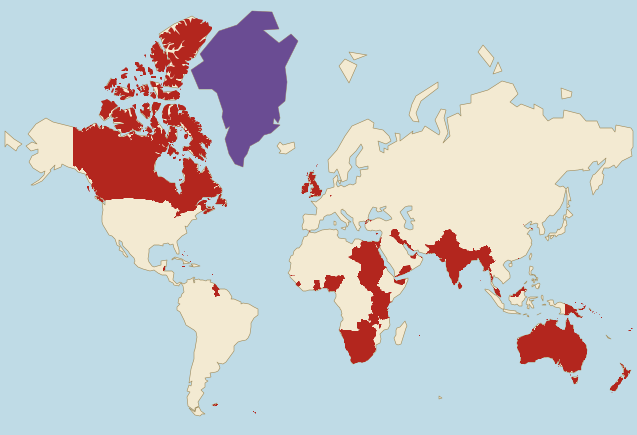
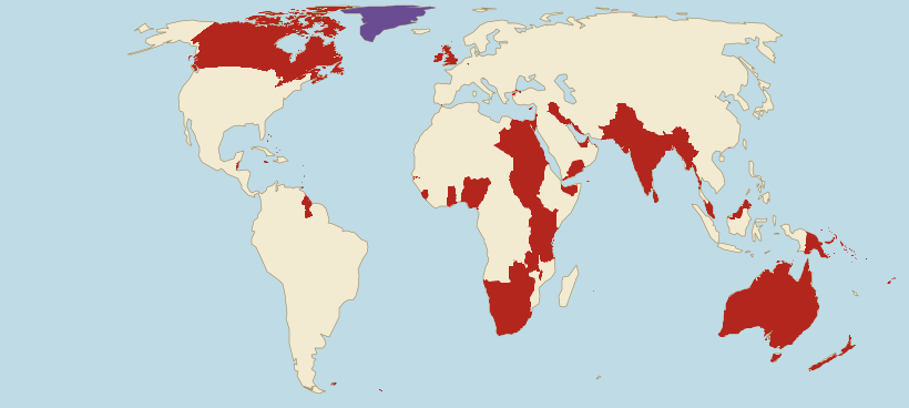
- British Empire (1920)
- Greenland
Borders: Cliopatria (Seshat Global History Databank), licensed CC BY 4.0, modified. Land: Natural Earth.
- On Mercator, the empire looks only 2.3 times bigger than Greenland. In reality it was 16.6 times bigger.
- On Mercator, the empire looks 2.4 times bigger than the whole of Africa. In reality it was only 1.2 times bigger.
- Mercator does not even enlarge the empire evenly. Compared with land on the equator, the part of the empire within present-day Canada grows on this map 5.1 times on average and the part within India 1.2 times, so the first grows 4.3 times as much.
British Empire vs Russia: guess, then check
At its peak, was the British Empire bigger than present-day Russia?
British Empire size next to today's countries
The empire's area in 1920 compared with selected countries, using the site's verified figures. The second line shows how the same comparison looks on a Mercator map.
- RussiaArea: 17.1 million km²The empire was 2.1 times larger.On Mercator it looks about the same size.
- CanadaArea: 9.98 million km²The empire was 3.6 times larger.On Mercator it looks 1.6 times larger.
- United StatesArea: 9.83 million km²The empire was 3.7 times larger.On Mercator it looks 3.6 times larger.
- IndiaArea: 3.29 million km²The empire was 11.0 times larger.On Mercator it looks 20.9 times larger.
- United KingdomArea: 240,000 km²The empire was 147.3 times larger.On Mercator it looks 116.1 times larger.
- PolandArea: 310,000 km²The empire was 115.1 times larger.On Mercator it looks 98.2 times larger.
Present-day countries inside the British Empire of 1920
We measure on the drawn outline and the country shapes the site uses. A country counts as wholly inside when at least 95% of its area lies within the outline (half for microstates), and as partly inside when at least 5,000 km² of its territory does. The outline only touches the edge of some countries on the second list.
Wholly inside (43)
- Canada
- Australia
- India
- Sudan
- South Africa
- Egypt
- Tanzania
- Nigeria
- Pakistan
- Namibia
- Zambia
- Myanmar
- South Sudan
- Kenya
- Botswana
- Papua New Guinea
- Zimbabwe
- Malaysia
- New Zealand
- Uganda
- Ghana
- United Kingdom
- Guyana
- Bangladesh
- United Arab Emirates
- Sierra Leone
- Ireland
- Sri Lanka
- Lesotho
- Israel
- Jamaica
- Palestine
- Brunei
- Cyprus
- Mauritius
- Dominica
- Bahrain
- Saint Lucia
- Singapore
- Barbados
- Grenada
- Saint Vincent and the Grenadines
- Seychelles
Partly inside (26)
The figure next to each name is the share of the country's area inside the outline.
- Libya 36%
- Yemen 67%
- Iraq 62%
- Iran 6%
- Malawi 72%
- Cameroon 10%
- Türkiye 3%
- Solomon Islands 90%
- Belize 89%
- China <1%
- Somalia 4%
- Fiji 90%
- Thailand 3%
- Eswatini 95%
- Oman 5%
- Indonesia <1%
- Democratic Republic of the Congo <1%
- Falkland Islands 94%
- Bahamas 82%
- Saudi Arabia <1%
- Gambia 91%
- Mozambique 1%
- Angola <1%
- Senegal 3%
- Ethiopia <1%
- Eritrea 4%
How the British Empire grew and shrank
Ten versions of the border from the Cliopatria database show selected stages in the empire's growth and decline, from 1713 to 1996. The older outlines have large gaps in North America, so we do not use them to calculate how fast the empire grew. The years 1953 and 1962 show successive stages of decolonisation.
British Empire in 1713
710,000 km² · 2% of the largest extent
The year of the Peace of Utrecht, six years after the union of England and Scotland created the Kingdom of Great Britain in 1707. The outline covers Great Britain and Ireland, the colonies on the east coast of North America, Nova Scotia and Newfoundland, Jamaica and other Caribbean islands, and Minorca. Gibraltar, which Britain gained in the same peace, is too small to show on the map, and the database does not count the lands around Hudson Bay yet.
British Empire in 1763
2.3 million km² · 6% of the largest extent
The year of the Peace of Paris, which ended the Seven Years' War. France gave Britain Canada and the lands east of the Mississippi, and Spain gave up Florida. The outline covers the colonies from Newfoundland to Florida, Quebec and Montreal on the St Lawrence, Fort Detroit on the Great Lakes and Bengal, where the British East India Company took effective power after the Battle of Plassey in 1757. Most of the land between the Appalachians and the Mississippi lies outside the outline: the Royal Proclamation of 1763 reserved it for Indigenous peoples, and the British held mainly forts there.
British Empire in 1783
1.5 million km² · 4% of the largest extent
The year of the Peace of Paris, in which Britain recognised the independence of the United States, declared in 1776. The Thirteen Colonies now lie outside the outline, and Florida and Minorca went back to Spain. What is left is Quebec, Nova Scotia and Newfoundland, the Caribbean islands and Bengal with neighbouring lands in India. The outline still includes Fort Detroit, which the British handed over to the United States only in 1796.
British Empire in 1815
3.32 million km² · 9% of the largest extent
The year of the Congress of Vienna and the Battle of Waterloo, which ended the Napoleonic Wars. Britain kept many of its gains from these wars, among them the Cape Colony, Ceylon, Malta, Mauritius, Trinidad and part of Guiana. The outline also covers Canada along the St Lawrence, a large part of India from Bengal to Madras and Hyderabad, and the area around Sydney, where the first settlers arrived in 1788.
British Empire in 1880
15.1 million km² · 42% of the largest extent
Since 1858 the British Crown has ruled India directly, and in 1877 Queen Victoria was proclaimed Empress of India in Delhi. The outline covers Canada, which became a dominion in 1867 and took over the Hudson's Bay Company lands in 1870, although the database counts only their south so far. It also shows Australia, omitting the interior of the western part of the continent, New Zealand, the Cape Colony and Natal, the Transvaal, taken in 1877 and given back to the Boers in 1881, and Cyprus, Aden, Malaya, Singapore, Hong Kong and Fiji.
British Empire in 1900
27 million km² · 75% of the largest extent
After the scramble for Africa the outline covers Egypt, occupied by the British since 1882 though still formally under the Ottoman sultan, Sudan, ruled jointly by Britain and Egypt since 1899, the lands of present-day Kenya and Uganda, Rhodesia and colonies in West Africa. The Boer War is under way: in 1900 Britain annexed both Boer republics, the Orange Free State and the Transvaal. Canada now reaches the Yukon, and Australia, a year before it united into one country, lies wholly inside the outline. Northern Nigeria, where the British declared a protectorate in 1900 but completed their conquest only in 1903, is still outside it.
British Empire in 1920
36 million km² · the largest extent
The largest extent in this set. After the First World War, Britain and the dominions took over former German colonies, among them Tanganyika and South West Africa, and Ottoman lands, Palestine and Mesopotamia (most of present-day Iraq), as League of Nations mandates. Egypt is still a British protectorate, and the whole of Ireland is part of the United Kingdom. The outline covers all of Canada with the Arctic islands, Australia, New Zealand, India with Burma and much of Africa, from Egypt to the Cape of Good Hope.
British Empire in 1953
8.84 million km² · 25% of the largest extent
The year Elizabeth II was crowned. India and Pakistan became independent in 1947, Burma and Ceylon in 1948. Canada, Australia, New Zealand and the Union of South Africa are now independent states that share their monarch with Britain, so the outline leaves them out. What remains is mostly colonies in Africa, from Sudan and the Gold Coast to Rhodesia, along with Malaya, Singapore and Hong Kong, Cyprus and Malta, Aden, protectorates on the Persian Gulf and colonies in the Caribbean.
British Empire in early 1962
3.85 million km² · 11% of the largest extent
Early 1962, before Jamaica became independent in August and Uganda in October. Ghana and Nigeria are already independent. The outline still includes Kenya and Uganda, Rhodesia, Singapore and Hong Kong, and colonies in the Caribbean, among other territories. This map shows decolonisation in progress, not the situation at the end of the year.
British Empire in 1996
260,000 km² · <1% of the largest extent
The last full year before Hong Kong was handed over to China on 1 July 1997. This marked a symbolic end to the imperial era, although Britain retained overseas territories. Most colonies became independent in the 1950s and 1960s, among them Sudan in 1956, Ghana in 1957, Nigeria in 1960 and Kenya in 1963, while Rhodesia did so as Zimbabwe only in 1980. Apart from the United Kingdom, the outline now covers only Hong Kong, the Falklands and a few small islands.
Why the British Empire's border is approximate
The empire included colonies, protectorates, mandates, Indian princely states and self-governing dominions. The dominions became independent gradually. The Statute of Westminster of 1931 confirmed their legislative independence; Australia adopted it in 1942 and New Zealand in 1947. We therefore include the dominions on our map of 1920 but leave them out in 1953. Sharing a monarch did not mean remaining subject to Britain.
The older outlines have large gaps. Most of Rupert's Land, about 3.9 million km² around Hudson Bay, appears in the database only from 1908, although Canada acquired it in 1870. The Arctic islands, transferred to Canada in 1880, are included only from 1911. The 1880 outline also omits the interior of Western Australia. These are limitations of the reconstruction, not dates when the lands joined the empire.
The 1920 outline also covers disputed or occupied land that was not formally part of the empire: part of the desert in eastern Libya, whose borders with Egypt and Sudan were settled only in the 1920s and 1930s, part of south-western Persia, today's Iran, although Persia remained independent, and the area around the Turkish Straits, occupied by the Allies from 1918 to 1923. The coast around Muscat is in the outline too, although the Sultanate of Oman was formally independent. That is why Libya, Iran, Türkiye and Oman appear on the list of countries partly inside the outline. Kuwait and Qatar, on the other hand, British protectorates at the time, lie almost wholly outside that year's outline.
The figures describe the drawn outline, fitted to the Natural Earth coastline. We added territories stored separately in the database: Australia, a self-governing dominion from 1901, and Natal, a British colony from 1843, incorrectly named the Natalia Republic in the source. We used their outlines for the relevant years. We also removed clear errors: pieces of the United States in 1920, the Republic of Ireland in later years, former Italian Somaliland in 1953 and Oman in 1962.
British Empire: frequently asked questions
At its peak in 1920, the outline from the Cliopatria database covers about 36 million km² (13.9 million square miles), or 24% of all the land on Earth. That is 2.1 times the area of present-day Russia, 3.7 times the area of the United States, 147.3 times the area of the United Kingdom itself and 115.1 times the area of Poland.
In the early 1920s. After the First World War, Britain and the dominions took over former German colonies, Palestine and Mesopotamia as League of Nations mandates. In the Cliopatria database the outline is almost the same size from 1918 to 1921 and then shrinks: in 1922 Egypt became formally independent and most of Ireland formed the Irish Free State.
Yes. The 1920 outline is 1.3 times the size of the Mongol Empire's outline of 1279, measured the same way from the same database. The Mongol Empire, though, was one continuous territory in Asia and Europe, while British lands lay on every inhabited continent.
Yes. In 1920 the empire was 2.1 times bigger than present-day Russia. On a Mercator map, though, it looks about the same size, because Russia lies much farther north and grows more on that map than the empire, a large part of which lay in the tropics.
The outline of 1920 covers 43 present-day countries wholly and 26 partly. Wholly inside are Canada, Australia, India and Sudan, among others. Partly inside are Iraq and Yemen, among others, as well as pieces of Libya, Iran and Türkiye that the database counts as disputed or occupied land after the First World War.
The Mercator projection enlarges regions more the farther they lie from the equator. Canada, the largest of the empire's territories, lies far to the north and grows on this map 5.1 times on average, India only 1.2 times. That is why on Mercator the empire looks 2.4 times bigger than Africa, although it was really only 1.2 times bigger.
The United States grew out of thirteen British colonies on the east coast of North America. They declared independence in 1776, and Britain recognised it in the Peace of Paris of 1783. Florida was British from 1763 to 1783. On the map the colonies appear in the outlines of 1713 and 1763; the 1783 version still includes Fort Detroit, handed over to the United States in 1796.
Gradually, over the decades after the Second World War. India and Pakistan became independent in 1947, and most colonies in Africa and the Caribbean in the 1950s and 1960s. The handover of Hong Kong to China on 1 July 1997 is often taken as the symbolic end of the empire. Britain nevertheless retained overseas territories, among them Gibraltar, the Falklands and Bermuda.
Sources and method
- Borders: Cliopatria (Seshat Global History Databank), licensed CC BY 4.0, modified: fitted to the coastline and simplified. Cliopatria (GitHub) · CC BY 4.0
- Coastline and present-day borders: Natural Earth, public domain. Natural Earth
- We measure the empire's area on the globe from the drawn outline. The apparent ratios on the maps use the same method as the projection comparator: the mean local area scale on a 0.5° grid. Projection comparator
- Present-day country areas come from the site's verified data. Data methodology
- Rupert's Land: The Canadian Encyclopedia (Historica Canada). Its transfer and that of the Arctic islands to Canada, and the Alaska boundary settlement: Government of Canada. The Canadian Encyclopedia: Rupert's Land · Government of Canada: historical boundaries
- The status of Australia and Natal and the dominions' gradual independence: historical accounts from the UK Parliament. UK Parliament: Australia · UK Parliament: Natal and South Africa · UK Parliament: dominion independence
- Confirmation of the border on the island of Ireland in 1925: House of Commons Library. House of Commons Library: the border in Ireland
- The handover of Hong Kong on 1 July 1997: Hong Kong Yearbook 1997, chapter 2. We describe historical facts in our own words; we do not reuse these sources' texts, photographs or maps. Hong Kong Yearbook 1997: the handover
- The independence dates of Jamaica, Trinidad and Tobago, and Uganda in 1962 and the transfer of the administration of former Italian Somaliland to Italy on 1 April 1950: Office of the Historian, US Department of State. Office of the Historian: Jamaican independence · Office of the Historian: independence of Trinidad and Tobago · Office of the Historian: Ugandan independence · Office of the Historian: Somaliland under Italian administration
- Oman was an independent state, despite British influence and military support. The British Foreign Secretary confirmed this in the House of Commons on 29 July 1957. Hansard 1957: Omani independence
- Earth's total land area, the basis of the empire's share: USGS. USGS: Earth's land area