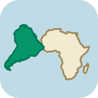
Russian Empire size in 1866 compared with the Mongol Empire and the USSR
At its peak in 1866, the Russian Empire covered about 22.5 million km² (8.69 million square miles), measured on the outline from the Cliopatria database. That is 2.3 times the area of the United States and 1.3 times present-day Russia, on three continents: Alaska alone took up 7% of the empire. Yet it was smaller than the Mongol Empire: it had 82% of its area, although on a Mercator map it looks 1.7 times bigger.
Russian Empire map: from Muscovy in 1462 to 2020
Move the year slider to see how a principality around Moscow grew into a state that reached from the Baltic to Alaska. Switch the projection to compare it with the rest of the world on a flat map and on the globe. Until 1547 the map shows the Grand Principality of Moscow, until 1721 the Tsardom of Russia, from 1721 the Russian Empire and in 2020 the Russian Federation.
1866 22.5 million km², the largest extent
This year's outline already includes Samarkand, taken in 1868, and Batumi, annexed in 1878. We removed the west of present-day Turkmenistan, which the database counts as part of the empire before 1869, when Russians founded their first port there, Krasnovodsk.
- Russian Empire
- Brown lines: present-day borders
Boundaries: Cliopatria (Seshat Global History Databank), licensed CC BY 4.0, modified: fitted to the coastline and simplified. Coastline and present-day borders: Natural Earth. Historical extents are approximate. Cliopatria · CC BY 4.0
Russian Empire on Mercator and Equal Earth maps
The Mercator projection enlarges regions more the farther they lie from the equator. Both maps below use the explorer's scale and show the world from 60°S to 84°N. Red is the empire in 1866; purple is Greenland.
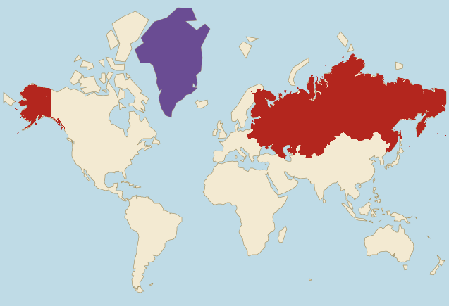
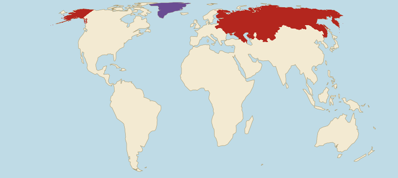
- Russian Empire (1866)
- Greenland
Borders: Cliopatria (Seshat Global History Databank), licensed CC BY 4.0, modified. Land: Natural Earth.
- On Mercator, the empire looks 2.9 times bigger than the whole of Africa. In reality Africa was 1.3 times bigger than the empire.
- On Mercator, the empire even looks 1.2 times bigger than the British Empire, although it had only 63% of its area.
- Mercator does not even enlarge the empire evenly. Compared with land on the equator, the part of the empire in Alaska, now in the United States, grows on this map 5.5 times on average and the part within present-day Kazakhstan 2.3 times, so the first grows 2.4 times as much.
Russian Empire vs Mongol Empire: guess, then check
At its peak, was the Russian Empire bigger than the Mongol Empire?
Russian Empire size next to today's countries
The empire's area in 1866 compared with selected countries, using the site's verified figures. The second line shows how the same comparison looks on a Mercator map.
- RussiaArea: 17.1 million km²The empire was 1.3 times larger.On Mercator it looks 1.2 times larger.
- United StatesArea: 9.83 million km²The empire was 2.3 times larger.On Mercator it looks 4.3 times larger.
- CanadaArea: 9.98 million km²The empire was 2.3 times larger.On Mercator it looks 1.9 times larger.
- ChinaArea: 9.6 million km²The empire was 2.3 times larger.On Mercator it looks 6.4 times larger.
- BrazilArea: 8.51 million km²The empire was 2.6 times larger.On Mercator it looks 11 times larger.
- AustraliaArea: 7.69 million km²The empire was 2.9 times larger.On Mercator it looks 10 times larger.
Present-day countries inside the Russian Empire of 1866
We measure on the drawn outline and the country shapes the site uses. A country counts as wholly inside when at least 95% of its area lies within the outline (half for microstates), and as partly inside when at least 5,000 km² of its territory does. Crimea, annexed by Russia in 1783, is counted as part of Ukraine, within its internationally recognised borders.
Partly inside (7)
The figure next to each name is the share of the country's area inside the outline.
- United States 16%
- Ukraine 88%
- Uzbekistan 64%
- Kyrgyzstan 68%
- Poland 39%
- Moldova 88%
- Tajikistan 14%
How the Russian Empire got so big: from Moscow to the Pacific and Alaska
Ten versions of the border from the Cliopatria database, from 1462 to 2020, show how the outline grew about 71 times in four centuries, up to 1866. It grew fastest in the 17th century, when Russians crossed the whole of Siberia to the Pacific. In the 19th century the empire expanded into Central Asia and the Far East, and sold Alaska. The last view, 2020, shows today's Russian Federation, without Poland, Finland, the Baltic states, Belarus, Ukraine, the South Caucasus, Central Asia and Alaska.
Grand Principality of Moscow in 1462
320,000 km² · 1% of the largest extent
The year Ivan III came to power. The Grand Principality of Moscow covers Moscow, Vladimir and the lands to the north as far as Vologda, about the size of present-day Italy. Until 1480 it still recognises the overlordship of the Horde khans. Novgorod, Tver and Ryazan, all still independent, lie outside it, and the Khanate of Kazan borders it to the east.
Grand Principality of Moscow in 1505
2.11 million km² · 9% of the largest extent
The year Ivan III died. During his reign Moscow annexed Novgorod (1478), with its vast northern lands reaching the White Sea and the Urals, and Tver (1485), which is why the outline is more than six times as large as in 1462. In 1480 Moscow stopped recognising the Horde's overlordship. Pskov, Ryazan and Smolensk, then Lithuanian, are still outside the outline.
Tsardom of Russia in 1598
4.77 million km² · 21% of the largest extent
The year Tsar Feodor I died, the last of the Rurik dynasty. His father, Ivan IV the Terrible, took the title of tsar in 1547, conquered Kazan (1552) and Astrakhan (1556), and in 1582 Yermak's Cossacks began the conquest of the Khanate of Sibir. The outline already includes Tobolsk, founded in 1587, and Smolensk, taken from Lithuania in 1514. Kyiv lies outside it: since the Union of Lublin of 1569 it has belonged to the Polish Crown.
Tsardom of Russia in 1653
11.4 million km² · 51% of the largest extent
Sixty years passed between the founding of Tobolsk and the first Russian settlement on the Sea of Okhotsk in 1647. In that time Russians crossed the whole of Siberia and founded Yakutsk in 1632. The outline already reaches the Anadyr in Chukotka and is more than twice as large as in 1598. In the west, Smolensk and the Chernihiv lands have belonged to the Polish-Lithuanian Commonwealth since the Truce of Deulino of 1618. War broke out in 1654, and the Truce of Andrusovo (1667) and the Eternal Peace of 1686 then gave Russia Smolensk and Ukraine east of the Dnieper with Kyiv.
Russian Empire in 1725
14.3 million km² · 63% of the largest extent
The year Peter the Great died. In 1721 he took the title of emperor, and from then on the state was called the Russian Empire. After the Great Northern War, ended by the Treaty of Nystad (1721), Russia holds St Petersburg, founded in 1703, Estonia, Livonia with Riga and Vyborg on the Baltic. The Treaty of Nerchinsk of 1689 set the border with China, and Russia gave up the Amur valley.
Russian Empire in 1795
16.6 million km² · 74% of the largest extent
The year of the third partition of the Polish-Lithuanian Commonwealth. After the partitions of 1772, 1793 and 1795 the outline covers Vilnius, Kaunas, Grodno, Minsk, Pinsk, Lutsk, Zhytomyr and Kamianets-Podilskyi, and Courland, a fief of the Commonwealth annexed the same year. Warsaw and Białystok went to Prussia, Kraków and Lviv to Austria. Earlier, Russia annexed Crimea (1783) and the Black Sea coast, where Odesa was founded in 1794. Across the Pacific the outline includes the first Russian settlements in Alaska, among them on Kodiak Island.
Russian Empire in 1815
17.2 million km² · 76% of the largest extent
The year of the Congress of Vienna. Most of the Duchy of Warsaw became the Kingdom of Poland, with Tsar Alexander I as its king, so Warsaw lies inside the outline. Since 1809 the empire has also held Finland as an autonomous Grand Duchy, since 1812 Bessarabia and since 1801 eastern Georgia. In California a Russian trading company runs Fort Ross, north of San Francisco.
Russian Empire in 1866
22.5 million km² · the largest extent
The largest extent in this set, a year before Russia sold Alaska to the United States for 7.2 million dollars. The outline covers the lands on the Amur and Ussuri with Vladivostok, gained from China in 1858 and 1860, most of the Caucasus with Yerevan, and the Kazakh steppe as far as Tashkent, taken in 1865. Three years earlier Poland's January Uprising broke out; after its defeat thousands of its participants were exiled to Siberia.
Russian Empire in 1914
22.2 million km² · 99% of the largest extent
The last year of peace before the First World War. The empire has lost Alaska and southern Sakhalin, ceded to Japan by the Treaty of Portsmouth in 1905, but has conquered Central Asia: Samarkand (1868), the Khanate of Kokand (1876) and the Turkmen lands as far as Merv, taken from 1881 to 1884. The emirates of Bukhara and Khiva became its protectorates. In 1878 the empire annexed Kars and Batumi, and in 1914 it made Tuva a protectorate. German troops took Warsaw in August 1915, and in 1917 the empire collapsed.
Russian Federation in 2020
16.7 million km² · 74% of the largest extent
Today's Russian Federation. After the empire collapsed in 1917, most of its lands joined the Soviet Union in 1922, which broke up in December 1991. The outline shows Russia within its internationally recognised borders, that is without Crimea, which the site treats as part of Ukraine. Outside it lie the former lands of the empire that now belong to other states: Poland, Finland, Lithuania, Latvia, Estonia, Belarus, Ukraine, Moldova, the countries of the South Caucasus and Central Asia, and Alaska. The eastern tip of Chukotka beyond the 180th meridian is missing from the outline.
Why the Russian Empire's border is approximate
The Cliopatria database draws the state as one whole, although it included lands of different status. The Grand Duchy of Finland and the Kingdom of Poland had their own offices and laws, and the emirates of Bukhara (from 1868) and Khiva (from 1873) and, from 1914, Tuva were protectorates with rulers of their own. That is why the 1914 outline covers almost all of present-day Uzbekistan and Turkmenistan.
The older outlines have gaps. Kamchatka, taken over from 1697, appears in the database only from 1734, and the interior of Alaska only from 1846, although the border between Russian America and British lands was set in 1825. No outline includes the eastern tip of Chukotka beyond the 180th meridian: the database cuts its polygons there, so on the map Chukotka breaks off along that line. This is a limitation of the reconstruction, not a border of the state.
In places the 1866 outline runs ahead of history: it includes Samarkand, taken in 1868, and Batumi, annexed in 1878. We removed the west of present-day Turkmenistan, where Russians founded their first foothold, Krasnovodsk, only in 1869, and narrow strips of present-day China, Canada and Norway that come from border offsets in the source. We left out the database's rows for 1900 to 1904, which include Manchuria, occupied at the time, and for 1915, which includes Kraków, although Russian troops never took it.
The 2020 outline shows Russia within its internationally recognised borders. The database's row for 2014 to 2023 includes Crimea, which the site treats as part of Ukraine within its internationally recognised borders (basis: UN General Assembly resolution 68/262 of 27 March 2014), so we removed the territory of Ukraine from it. Strips of neighbouring countries a few kilometres wide remain along the borders, and the database cuts Chukotka at the 180th meridian. That is why the outline covers 16.7 million km², while Russia's area in the site's data is 17.1 million km².
The figures describe the drawn outline, fitted to the Natural Earth coastline. Crimea, annexed by Russia in 1783, is counted on the country list as part of Ukraine, within its internationally recognised borders. The outline of the Soviet Union in 1977, which the questions below compare with the empire, comes from the same database and is measured the same way, but the map does not show it.
Russian Empire: frequently asked questions
At its peak in 1866, the outline from the Cliopatria database covers about 22.5 million km² (8.69 million square miles), or 15% of all the land on Earth. That is more than twice the area of each of the United States, Canada and China, and 1.3 times present-day Russia.
In the mid-1860s, before the sale of Alaska in 1867. The empire later conquered most of Central Asia, but those lands only roughly made up for Alaska: the 1914 outline has 99% of the area of the 1866 one, despite the new conquests in Turkestan.
Yes. Russian traders settled on the Aleutian Islands and Kodiak in the 18th century, and a Russian trading company ran the colony from 1799. In the 1866 outline, the part in present-day Alaska covers about 1.47 million km² (568,000 square miles), 7% of the empire. Russia agreed to sell it to the United States on 30 March 1867 and handed it over on 18 October. From 1812 to 1841 the same company also ran Fort Ross in California.
They were about the same size. The outline of the Soviet Union in 1977, from the same database and measured the same way, covers about 21.9 million km² (8.44 million square miles). The Soviet Union lacked Finland, most of the Kingdom of Poland and Alaska, but held Tuva, Lviv and eastern Galicia, Transcarpathia, the Kaliningrad region, southern Sakhalin and the southern Kurils.
Yes. The outline of the Russian Federation in 2020 covers about 16.7 million km² (6.43 million square miles), or 74% of the empire's 1866 outline. It lacks lands that have belonged to other states since 1917, among them Poland, Finland, Lithuania, Latvia, Estonia, Belarus and Ukraine, as well as Alaska, sold in 1867. The area of Russia in the site's data is 17.1 million km², without Crimea.
No. The 1866 outline has 82% of the area of the Mongol Empire's outline of 1279, measured the same way from the same database. On a Mercator map, though, the Russian Empire looks 1.7 times bigger, because more of it lay far to the north.
No. The 1866 outline has 63% of the area of the British Empire in 1920, measured the same way from the same database. On a Mercator map, though, the Russian Empire looks 1.2 times bigger, because the British held large lands in the tropics, which that map hardly enlarges.
The outline of 1866 covers 10 present-day countries wholly and 7 partly. Wholly inside are Russia, Kazakhstan, Finland and Belarus, among others; partly inside are Poland, Ukraine and the United States with Alaska, among others. By 1914 the empire had added most of Central Asia.
The Mercator projection enlarges regions more the farther they lie from the equator, and almost the whole empire lay north of the 40th parallel. Compared with the equator, the map enlarges it 4.3 times on average. That is why on Mercator the empire looks 2.9 times bigger than Africa, although Africa was really 1.3 times bigger. Next to Greenland it looks only 2.7 times bigger, although it was really 10.4 times bigger.
In 1917. Tsar Nicholas II abdicated in March, and in September Russia was proclaimed a republic. Finland declared independence on 6 December 1917, and Poland, Lithuania, Latvia and Estonia became independent in 1918. In 1922 the Bolsheviks founded the Soviet Union on most of the former empire's lands.
Sources and method
- Borders: Cliopatria (Seshat Global History Databank), licensed CC BY 4.0, modified: fitted to the coastline and simplified. Cliopatria (GitHub) · CC BY 4.0
- Coastline and present-day borders: Natural Earth, public domain. Natural Earth
- We measure the empire's area on the globe from the drawn outline. The apparent ratios on the maps use the same method as the projection comparator: the mean local area scale on a 0.5° grid. Projection comparator
- Present-day country areas come from the site's verified data. Data methodology
- The creation of the Kingdom of Poland in 1815, the tsar's title of King of Poland, the Białystok district kept by Russia and the Free City of Kraków: the Polish Integrated Educational Platform. ZPE (in Polish): the Congress of Vienna and Poland
- Exiles after the January Uprising, Benedykt Dybowski's research on Lake Baikal and the capture of Warsaw by German troops in August 1915: dzieje.pl, the portal of the Museum of Polish History. dzieje.pl (in Polish): Polish exiles in Irkutsk · dzieje.pl (in Polish): the capture of Warsaw in 1915
- The sale of Alaska in 1867, the Treaty of Portsmouth of 1905 and Finland's declaration of independence on 6 December 1917: Office of the Historian, US Department of State. Office of the Historian: the purchase of Alaska · Office of the Historian: the Treaty of Portsmouth · Office of the Historian: Finnish independence
- Fort Ross in California, a Russian trading company settlement from 1812 to 1841: California State Parks. California State Parks: Fort Ross
- The basis of the corrections to the 1866 outline: the border with China on the Amur and Ussuri (Encyclopedia of Russian History), the 1825 convention with Britain (The Canadian Encyclopedia), the border with Norway set in 1826 (Store norske leksikon) and Krasnovodsk, founded in 1869, as Russia's first foothold in Turkmenistan (US Library of Congress). We describe the facts in our own words; we do not reuse these sources' texts, photographs or maps. Encyclopedia of Russian History: the Treaty of Peking · The Canadian Encyclopedia: the Alaska boundary · Store norske leksikon (in Norwegian): Norway's borders · Library of Congress: Turkmenistan in the Russian Empire
- The basis for removing Crimea from the 2020 outline of the Russian Federation, that is for treating it as part of Ukraine within its internationally recognised borders: UN General Assembly resolution 68/262 of 27 March 2014. UN: resolution 68/262 on the territorial integrity of Ukraine
- Earth's total land area, the basis of the empire's share: USGS. USGS: Earth's land area