
How big was Poland through history?
At its largest, in 1619, the Polish-Lithuanian Commonwealth covered about 940,000 km², measured on the outline from the Cliopatria database. That is 3.0 times the area of present-day Poland. Greenland is only 2.3 times bigger, yet on a Mercator map it looks 13.8 times bigger.
Poland's borders from 966 to 2024
Move the year slider to see how the borders changed. Switch the projection to compare Poland with the rest of the world on a flat map and on the globe.
1619 940,000 km², the largest extent
- Polish-Lithuanian Commonwealth
- Brown lines: present-day borders
Boundaries: Cliopatria (Seshat Global History Databank), licensed CC BY 4.0, modified: fitted to the coastline and simplified. Coastline and present-day borders: Natural Earth. Historical extents are approximate. Cliopatria · CC BY 4.0
Mercator versus true scale
The Mercator projection enlarges regions more the farther they lie from the equator. Both maps below use the explorer's scale and show the world from 60°S to 84°N. Red is the Commonwealth in 1619; purple is Greenland.
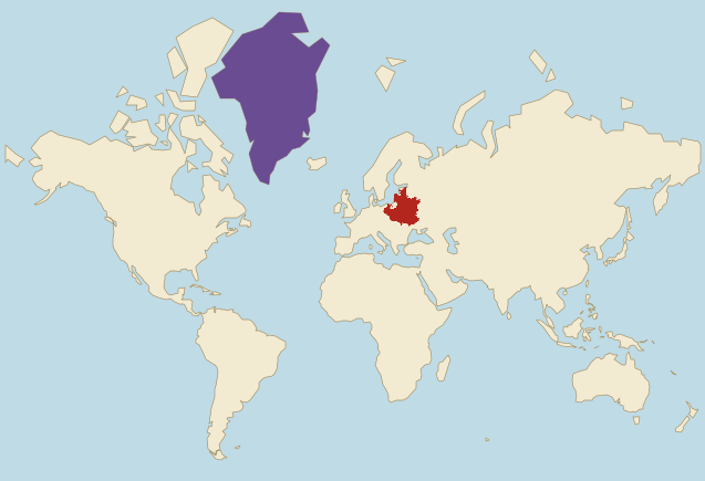
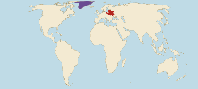
- Polish-Lithuanian Commonwealth (1619)
- Greenland
Borders: Cliopatria (Seshat Global History Databank), licensed CC BY 4.0, modified. Land: Natural Earth.
- On Mercator, Greenland looks 13.8 times bigger than the Commonwealth. In reality it is only 2.3 times bigger.
- On Mercator, the Commonwealth looks 2.1 times bigger than Egypt. In reality its outline has 94% of Egypt's area, because Egypt lies much closer to the equator and grows less on this map.
- Mercator does not even enlarge the Commonwealth evenly. Compared with land on the equator, the part within present-day Latvia grows on this map 3.3 times on average, and the part within present-day Ukraine 2.4 times.
Estimate first, then check
At its largest, was the Polish-Lithuanian Commonwealth bigger than present-day Türkiye?
The Commonwealth next to today's countries
The Commonwealth's area in 1619 compared with selected countries, using the site's verified figures. The second line shows how the same comparison looks on a Mercator map.
- PolandArea: 310,000 km²The Commonwealth was 3.0 times larger.On Mercator it looks 3.1 times larger.
- GermanyArea: 360,000 km²The Commonwealth was 2.6 times larger.On Mercator it looks 2.9 times larger.
- UkraineArea: 600,000 km²The Commonwealth was 1.6 times larger.On Mercator it looks 1.8 times larger.
- SwedenArea: 440,000 km²The Commonwealth was 2.1 times larger.On Mercator it looks 1.2 times larger.
- TürkiyeArea: 780,000 km²The Commonwealth was 1.2 times larger.On Mercator it looks 2.0 times larger.
- EgyptArea: 1 million km²The Commonwealth had 94% of this area.On Mercator it looks 2.1 times larger.
Present-day countries inside the Commonwealth of 1619
We measure on the drawn outline and the country shapes the site uses. A country counts as wholly inside when at least 95% of its area lies within the outline, and as partly inside when at least 5,000 km² of its territory does. Present-day Poland is on the second list: Silesia and Western Pomerania then belonged to other states, and Masuria to Ducal Prussia, a Polish fief.
How Poland's borders changed
Twelve versions of the border from the Cliopatria database, from the baptism of Mieszko I to today. From 966 to 1619 the state's area grew about 9 times. The database cannot show the years from 1795 to 1918, apart from the Duchy of Warsaw, or the Second Republic faithfully, so we describe them in words.
966
110,000 km² · 11% of the largest extent
The year Mieszko I was baptised, taken as the beginning of the Polish state. The outline covers Greater Poland with Gniezno and Poznań and Masovia with Płock. Lesser Poland with Kraków and Silesia with Wrocław still lie outside it: they came under Piast rule towards the end of the 10th century.
1025
290,000 km² · 31% of the largest extent
The year Bolesław the Brave was crowned the first king of Poland. The outline now covers Lesser Poland, Silesia and Pomerania, as well as Lusatia, Moravia and the Cherven Towns with Przemyśl, won in wars with the neighbours. Lusatia stayed with Poland under the Peace of Bautzen of 1018.
1138
260,000 km² · 27% of the largest extent
The year Bolesław the Wrymouth died; he had brought Pomerania under his rule as far as Szczecin. His testament divided the country among his sons and began the period of fragmentation. The outline no longer covers Lusatia, Moravia or the Cherven Towns.
1250
220,000 km² · 23% of the largest extent
The country is divided into duchies ruled by different princes of the Piast dynasty, and the map shows them together. In 1241 a Mongol raid swept through Lesser Poland and Silesia, with the Battle of Legnica, but the Mongols did not hold these lands. Western Pomerania with Szczecin lies outside the outline.
1370
240,000 km² · 25% of the largest extent
The year Casimir the Great died, the last king of the Piast dynasty. His father Władysław the Short reunited most of the lands and was crowned king in 1320, and Casimir added Red Ruthenia with Lviv. Silesia stayed with Bohemia, and Gdańsk Pomerania had belonged to the Teutonic Order since 1308.
1410
230,000 km² · 25% of the largest extent
The year of the Battle of Grunwald. Since the Union of Krewo in 1385 Poland and Lithuania have been linked by the person of Władysław Jagiełło, but they are separate states and Lithuania is governed by Grand Duke Vytautas, so the map shows the Crown alone. Poland regained Gdańsk Pomerania only in 1466, after the Thirteen Years' War.
1619
940,000 km² · the largest extent
The largest extent in this set. The Union of Lublin of 1569 joined the Crown and the Grand Duchy of Lithuania into one state, the Polish-Lithuanian Commonwealth, which is why from this version on the outline also covers Lithuania with Vilnius. The Truce of Deulino, agreed with Russia in December 1618, gave the Commonwealth the lands of Smolensk and Chernihiv. The outline also includes Livonia with Riga, which the Swedes took in 1621.
1770
730,000 km² · 78% of the largest extent
The last version before the partitions. The Commonwealth lost Riga to Sweden in 1621, Smolensk and Chernihiv to Russia in 1667, and Kyiv for good in 1686. The database draws Courland, a fief of the Commonwealth, separately in this period.
1773
540,000 km² · 57% of the largest extent
After the First Partition of 1772, Prussia took Gdańsk Pomerania without Gdańsk itself, Austria took Galicia with Lviv and Przemyśl, and Russia took the lands around Polotsk and Vitebsk. Toruń also remained in the Commonwealth, although this outline leaves it out.
1793
220,000 km² · 24% of the largest extent
After the Second Partition of 1793, Prussia took Greater Poland with Poznań as well as Gdańsk and Toruń, and Russia took the lands around Minsk, Pinsk and Kamianets-Podilskyi. After the Kościuszko Uprising failed, the Third Partition of 1795 divided the rest of the state, and for 123 years there was no independent Polish state.
1812
150,000 km² · 16% of the largest extent
Napoleon created the Duchy of Warsaw in 1807 from lands of the Prussian partition and in 1809 enlarged it with Kraków and Lublin from the Austrian partition. Gdańsk was then a free city. After Napoleon's defeat the Congress of Vienna divided the Duchy in 1815: most of it went to Russia as the Kingdom of Poland, Poznań to Prussia, and Kraków became a free city. Bydgoszcz was a departmental capital of the Duchy, although this outline leaves it out.
2024
310,000 km² · 33% of the largest extent
Poland regained its independence in 1918. After the Second World War its borders were moved west: Wrocław, Szczecin, Gdańsk and Olsztyn came within them, while Vilnius and Lviv were left outside. The border has run this way ever since.
Why the border is approximate
Before the Piast state arose, the lands of present-day Poland were home to Slavic tribes, among them the Polans in Greater Poland, the Vistulans in Lesser Poland, the Silesians, the Masovians and the Pomeranians. Their territories cannot be drawn reliably and are not in the Cliopatria database, so the timeline starts in 966.
Medieval borders were often zones of influence rather than lines. From 1385 to 1569 Poland and Lithuania were two states, usually under one ruler, so for those years we show the Crown alone. The database also draws the two together in the 15th century, and their joint area then comes out even larger than the Commonwealth's in 1619, because Lithuania reached farther east. The Commonwealth's outline leaves out Ducal Prussia, although it was a Polish fief until 1657, but includes Courland, which was also a fief. The 1250 outline also covers Gdańsk Pomerania, although independent dukes ruled it at the time.
The Cliopatria database has gaps that we do not guess at. It does not draw the Kingdom of Poland created in 1815 on its own, only as part of the Russian Empire. Its outline of the Second Republic, which existed from 1918 to 1939, lacks Upper Silesia with Katowice and the Polish part of Cieszyn Silesia, and it assigns the Polish lands of 1945 to 1952 to the USSR. That is why the timeline goes from 1812 straight to today's borders.
The figures on this page describe the drawn outline. We clipped it to the Natural Earth coastline and extended it to the coast where it stopped short, which changed the peak area by 0.3%. Published estimates of the Commonwealth's area at its height are somewhat higher, because atlases differ on the eastern borders.
Frequently asked questions
The largest outline in this set is the Polish-Lithuanian Commonwealth in 1619: about 940,000 km² according to the Cliopatria database. That is 3.0 times present-day Poland and 2.6 times present-day Germany.
The Polish-Lithuanian Commonwealth was at its largest after the Truce of Deulino, agreed with Russia in December 1618, which gave it the lands of Smolensk and Chernihiv. It lost Riga in 1621, and Smolensk and Chernihiv in 1667. Poland and Lithuania together covered an even larger area in the 15th century, but they were then two states with a shared ruler.
Yes. In 1619 it was 1.2 times the size of present-day Türkiye. On a Mercator map it looks 2.0 times bigger, because it lies farther from the equator.
The 1619 outline wholly covers Belarus, Latvia and Lithuania, and partly Ukraine, Poland, Russia and Estonia. Present-day Poland is only partly inside, because Silesia and Western Pomerania then belonged to other states, and Masuria to Ducal Prussia.
The Mercator projection enlarges regions more the farther they lie from the equator. The Commonwealth lay in the northern mid-latitudes, so on this map it is on average 2.8 times larger than a region of the same size on the equator. Greenland grows even more, which is why on Mercator it looks 13.8 times bigger than the Commonwealth, although it is really only 2.3 times bigger.
After the Third Partition in 1795, Russia, Prussia and Austria divided the Commonwealth's lands. Until 1918 there were only states dependent on Napoleon or on the partitioning powers: the Duchy of Warsaw, the Kingdom of Poland tied to Russia, and the Free City of Kraków. The map shows the Duchy of Warsaw in 1812; the database does not draw the Kingdom of Poland on its own.
The Cliopatria database, the source of the borders, assigns Upper Silesia with Katowice to Germany throughout the interwar years. Its outline of the Second Republic would therefore be clearly too small, and it assigns the Polish lands of 1945 to 1952 to the USSR. Rather than show a wrong map, we go from 1812 straight to today's borders.
Sources and method
- Borders: Cliopatria (Seshat Global History Databank), licensed CC BY 4.0, modified: fitted to the coastline and simplified. Cliopatria (GitHub) · CC BY 4.0
- Coastline and present-day borders: Natural Earth, public domain. Natural Earth
- We measure the state's area in each year on the globe from the drawn outline. The apparent ratios on the maps use the same method as the projection comparator: the mean local area scale on a 0.5° grid. Projection comparator
- Present-day country areas come from the site's verified data. Data methodology
- Toruń after the First Partition and Bydgoszcz within the Duchy of Warsaw: the official histories of both cities. History of Toruń · History of Bydgoszcz