
How big was the Roman Empire?
At its peak in AD 117, the Roman Empire covered about 5.3 million km², measured on the outline from the Cliopatria database. That is 16.9 times the area of present-day Poland and 2.4 times the area of Greenland, yet on a Mercator map Greenland looks 3.9 times bigger than the empire.
The empire's extent from 264 BC to AD 475
Move the year slider to see how the extent changed. Switch the projection to compare the empire with the rest of the world on a flat map and on the globe.
AD 117 5.3 million km², the largest extent
- Roman Empire
- Brown lines: present-day borders
Boundaries: Cliopatria (Seshat Global History Databank), licensed CC BY 4.0, modified: fitted to the coastline and simplified. Coastline and present-day borders: Natural Earth. Historical extents are approximate. Cliopatria · CC BY 4.0
Mercator versus true scale
The Mercator projection enlarges regions more the farther they lie from the equator. Both maps below use the explorer's scale and show the world from 60°S to 84°N. Red is the empire in AD 117; purple is Greenland.
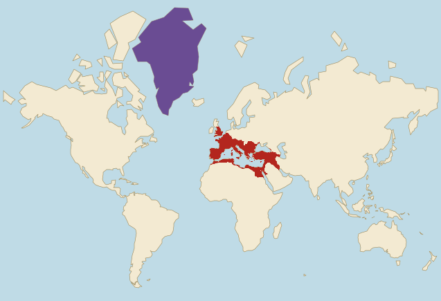
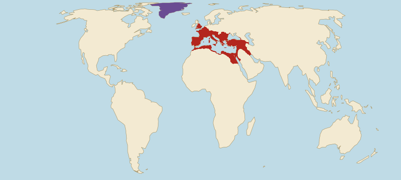
- Roman Empire (AD 117)
- Greenland
Borders: Cliopatria (Seshat Global History Databank), licensed CC BY 4.0, modified. Land: Natural Earth.
- On Mercator, Greenland looks 3.9 times bigger than the empire. In reality the empire was 2.4 times bigger than Greenland.
- On Mercator, the empire looks roughly as big as Brazil. In reality it had 62% of Brazil's area.
- Mercator does not even enlarge the empire evenly. Compared with land on the equator, Roman Britain grows on this map 2.7 times on average and Roman Egypt 1.3 times, so Britain grows 2.1 times as much.
Estimate first, then check
At its peak, was the Roman Empire bigger than the present-day United States?
The empire next to today's countries
The empire's area in AD 117 compared with selected countries, using the site's verified figures. The second line shows how the same comparison looks on a Mercator map.
- United StatesArea: 9.83 million km²The empire had 54% of this area.On Mercator it looks like 41% of this area.
- BrazilArea: 8.51 million km²The empire had 62% of this area.On Mercator it looks about the same size.
- AustraliaArea: 7.69 million km²The empire had 69% of this area.On Mercator it looks about the same size.
- IndiaArea: 3.29 million km²The empire was 1.6 times larger.On Mercator it looks 2.3 times larger.
- PolandArea: 310,000 km²The empire was 16.9 times larger.On Mercator it looks 11.0 times larger.
- ItalyArea: 300,000 km²The empire was 17.5 times larger.On Mercator it looks 16.3 times larger.
Present-day countries inside the empire of AD 117
We measure on the drawn outline and the country shapes the site uses. A country counts as wholly inside when at least 95% of its area lies within the outline (half for microstates), and as partly inside when at least 5,000 km² of its territory does. The outline only touches the edge of some countries on the second list.
Wholly inside (27)
Partly inside (21)
The figure next to each name is the share of the country's area inside the outline.
How the empire grew and shrank
Seven versions of the border from the Cliopatria database. From 264 BC to AD 117 the extent grew about 41 times.
264 BC
130,000 km² · 2% of the largest extent
The Roman Republic just before the First Punic War. The outline covers central and southern Italy; the Po Valley, Sicily and Carthage are still outside it.
144 BC
890,000 km² · 17% of the largest extent
Two years after the destruction of Carthage and Corinth. The outline now covers all of Italy including the Po Valley, Sicily, Sardinia and Corsica, the east and south of the Iberian Peninsula, Macedonia, the area around Corinth and the lands around Carthage in present-day Tunisia.
44 BC
2.38 million km² · 45% of the largest extent
The year Julius Caesar was assassinated. The outline covers Gaul up to the Rhine, most of the Iberian Peninsula, Greece, western Asia Minor, Syria and Cyrenaica. Egypt and Britain are still outside it, as is the north of the Iberian Peninsula, conquered only between 29 and 19 BC.
AD 14
3.55 million km² · 67% of the largest extent
The year Augustus died. The outline now includes Egypt, Judaea, Galatia in inner Asia Minor, the north of the Iberian Peninsula and most of the Balkans. In the north-west the border is the Rhine: after the defeat in the Teutoburg Forest (AD 9), Rome did not hold the land east of it.
AD 117
5.3 million km² · the largest extent
The largest extent in this set, in the year Trajan died. The outline reaches from Britain, without Scotland, to the Persian Gulf and includes Dacia, Armenia, Mesopotamia with Ctesiphon and Arabia Petraea with Petra. Trajan took Armenia and Mesopotamia between 114 and 116, and Hadrian gave them up soon after coming to power.
AD 395
4.15 million km² · 78% of the largest extent
Theodosius I died in January 395 and his sons took over: Honorius in the West and Arcadius in the East. From then on each half had its own emperor. Dacia, Armenia and Mesopotamia are no longer within the outline.
AD 475
2.67 million km² · 50% of the largest extent
The Western Empire's last year in the data: in 476 Odoacer deposed the emperor Romulus Augustulus. The Western outline covers Italy without Sicily, Dalmatia, the Alpine lands, part of Provence, the north-east of the Iberian Peninsula and northern Gaul, the so-called Domain of Soissons, which Cliopatria counts as part of the West. Africa, Britain and the south of the Iberian Peninsula are already outside it. The Eastern Empire lasted almost a thousand more years, until 1453.
Why the border is approximate
Ancient borders were rarely sharp lines. On the empire's edges lay zones of influence and client states that accepted Rome's authority without being provinces, such as the Bosporan Kingdom in Crimea. Any map of the extent has to choose one version, and atlas makers choose differently.
The largest extent did not last. Trajan took Ctesiphon in 116, and his successor Hadrian gave up Mesopotamia and Armenia soon after coming to power in 117. The AD 117 border therefore shows a state that lasted about a year.
The figures on this page describe the drawn outline. Cliopatria's polygons stop 5 to 25 km short of the coastline, so we extended them to the Natural Earth coast, which added 0.7% to the peak area. Published estimates of the empire's area differ from one another because they depend on the atlas used and on which lands are counted as under Roman control.
Frequently asked questions
At its peak in AD 117, the outline from the Cliopatria database covers about 5.3 million km². That is 16.9 times the area of Poland and 17.5 times the area of Italy.
Under the emperor Trajan, in 116 and 117. After taking Armenia and Mesopotamia, the empire reached from Britain to the Persian Gulf. Hadrian gave up these conquests soon after coming to power in 117.
No. In AD 117 the empire had 54% of the area of the present-day United States. On a Mercator map it looks even smaller, about 41% of the USA, because Alaska lies farther from the equator and grows more on that map.
The outline of AD 117 covers 27 present-day countries wholly and 21 partly. Wholly inside are Türkiye, France, Spain and Italy, among others; partly inside are Egypt, Iraq, Algeria and Romania, among others.
The Mercator projection enlarges regions more the farther they lie from the equator. The empire lay in the mid-latitudes, so on this map it is on average 1.7 times larger than a region of the same size on the equator. Greenland lies much farther north and grows even more, which is why on Mercator it looks 3.9 times bigger than the empire, even though the empire was 2.4 times bigger.
About a year. Trajan took Ctesiphon in 116, and his successor Hadrian gave up Mesopotamia and Armenia soon after coming to power in 117.
Sources and method
- Borders: Cliopatria (Seshat Global History Databank), licensed CC BY 4.0, modified: fitted to the coastline and simplified. Cliopatria (GitHub) · CC BY 4.0
- Coastline and present-day borders: Natural Earth, public domain. Natural Earth
- We measure the empire's area on the globe from the drawn outline. The apparent ratios on the maps use the same method as the projection comparator: the mean local area scale on a 0.5° grid. Projection comparator
- Present-day country areas come from the site's verified data. Data methodology