
How big was the Mongol Empire?
At its peak in 1279, the Mongol Empire covered about 27.4 million km², measured on the outline from the Cliopatria database. That is 87.6 times the area of present-day Poland and 1.6 times the area of present-day Russia, yet on a Mercator map Russia looks 1.5 times bigger than the empire.
The empire's extent from 1206 to 1294
Move the year slider to see how the extent changed. Switch the projection to compare the empire with the rest of the world on a flat map and on the globe.
1279 27.4 million km², the largest extent
- Mongol Empire
- Brown lines: present-day borders
Boundaries: Cliopatria (Seshat Global History Databank), licensed CC BY 4.0, modified: fitted to the coastline and simplified. Coastline and present-day borders: Natural Earth. Historical extents are approximate. Cliopatria · CC BY 4.0
Mercator versus true scale
The Mercator projection enlarges regions more the farther they lie from the equator. Both maps below use the explorer's scale and show the world from 60°S to 84°N. Red is the empire in 1279; purple is Greenland.
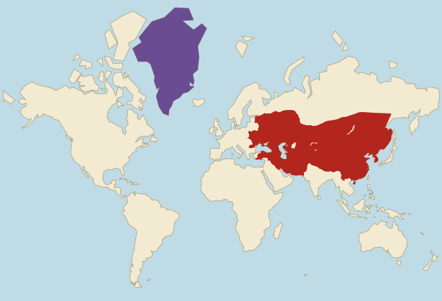
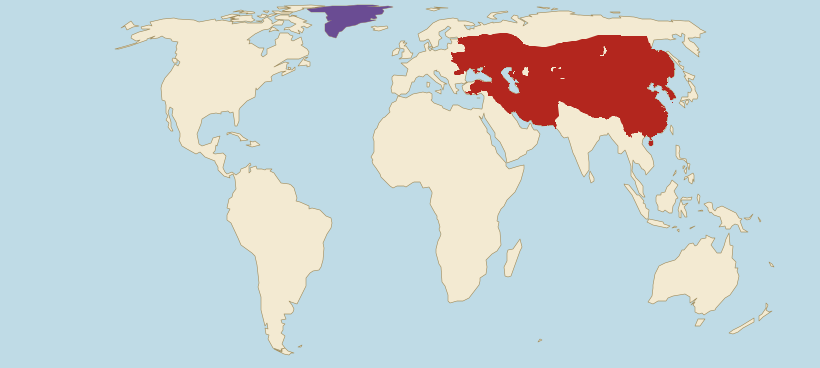
- Mongol Empire (1279)
- Greenland
Borders: Cliopatria (Seshat Global History Databank), licensed CC BY 4.0, modified. Land: Natural Earth.
- On Mercator, present-day Russia looks 1.5 times bigger than the empire. In reality the empire was 1.6 times bigger than Russia, which reaches farther north and grows more on this map.
- On Mercator, the empire looks only 1.6 times bigger than Greenland. In reality it was 12.6 times bigger.
- Mercator does not even enlarge the empire evenly. Compared with land on the equator, the part of the empire within present-day Russia grows on this map 3.0 times on average and the part within present-day Iran 1.4 times, so the first grows 2.1 times as much.
Estimate first, then check
At its peak, was the Mongol Empire bigger than present-day Russia?
The empire next to today's countries
The empire's area in 1279 compared with selected countries, using the site's verified figures. The second line shows how the same comparison looks on a Mercator map.
- RussiaArea: 17.1 million km²The empire was 1.6 times larger.On Mercator it looks like 68% of this area.
- ChinaArea: 9.6 million km²The empire was 2.9 times larger.On Mercator it looks 3.8 times larger.
- United StatesArea: 9.83 million km²The empire was 2.8 times larger.On Mercator it looks 2.5 times larger.
- BrazilArea: 8.51 million km²The empire was 3.2 times larger.On Mercator it looks 6.4 times larger.
- AustraliaArea: 7.69 million km²The empire was 3.6 times larger.On Mercator it looks 5.9 times larger.
- PolandArea: 310,000 km²The empire was 87.6 times larger.On Mercator it looks 68.6 times larger.
Present-day countries inside the empire of 1279
We measure on the drawn outline and the country shapes the site uses. A country counts as wholly inside when at least 95% of its area lies within the outline (half for microstates), and as partly inside when at least 5,000 km² of its territory does. The outline only touches the edge of some countries on the second list.
Wholly inside (15)
How the empire grew and split
Seven versions of the border from the Cliopatria database. From 1206 to 1279 the extent grew about 11 times.
1206
2.46 million km² · 9% of the largest extent
At a kurultai, a gathering of Mongol leaders by the Onon River, Temüjin took the title Genghis Khan. The outline covers most of present-day Mongolia and a strip of Transbaikalia in southern Siberia. Beijing and the Tangut state of Western Xia are still outside it.
1220
8.56 million km² · 31% of the largest extent
The war against the Khwarazmian Empire is under way: in 1220 the Mongols took Bukhara and Samarkand. The outline also includes Beijing, taken in 1215, the lands of the Qara Khitai with Kashgar, and Western Xia, whose ruler had accepted Mongol overlordship. Merv, Nishapur and Herat, taken in 1221, are still outside it.
1227
14.1 million km² · 51% of the largest extent
The year Genghis Khan died, in the summer of 1227, during the war against the Tanguts. The Mongols destroyed their state of Western Xia that same year. The outline now covers the lands of Khwarazm with Merv, Nishapur and Herat, as well as Kabul and Manchuria. Kaifeng, the capital of the Jin dynasty, is still outside it: the Jin held out until 1234.
1241
20.9 million km² · 76% of the largest extent
The year of the battles of Legnica (9 April) and Mohi on the Sajó river in Hungary. The outline covers the Rus' lands from Kyiv to Novgorod, although the Mongols never took Novgorod, along with the Volga region, the Caucasus, Iran down to the Persian Gulf and northern China after the fall of the Jin. In the west it reaches Galicia-Volhynia, including Chełm and Przemyśl, which are now in Poland. Kraków, Sandomierz, Legnica and Hungary lie outside it: Mongol armies ravaged these lands in 1241 but withdrew the next year, after the death of the Great Khan Ögedei.
1260
25.8 million km² · 94% of the largest extent
In 1259 the Great Khan Möngke died, and two of his brothers, Kublai and Ariq Böke, both claimed the title. Their war, from 1260 to 1264, ended the empire's unity. The outline for this year includes Baghdad, taken in 1258, Anatolia, Korea, Tibet and the Kingdom of Dali in present-day Yunnan. It also contains Aleppo and Damascus, which the Mongols took early in 1260 and lost after their defeat by the Mamluks at Ain Jalut in September. Most of southern China, still ruled by the Song dynasty, lies outside it.
1279
27.4 million km² · the largest extent
The largest extent in this set. In 1279 the naval battle of Yamen ended the Song dynasty, and all of China came under Kublai, who had ruled as emperor of the Yuan dynasty since 1271. The outline reaches from Korea to Anatolia and from Siberia to the Persian Gulf. Cliopatria draws a single state here, although the khanates already acted on their own and the Golden Horde and the Ilkhanate fought each other. Japan and Vietnam, which repelled Mongol invasions, lie outside it.
1294
25.6 million km² · 93% of the largest extent
Kublai died in February 1294. From this year Cliopatria draws four separate states: the Yuan dynasty in China and Mongolia, the Golden Horde on the steppes from present-day Moldova to western Siberia, the Ilkhanate from Anatolia to western Afghanistan and the Chagatai Khanate in Central Asia. In 1304 the khans made peace and recognised the Yuan emperor as their overlord, but only in name.
Why the border is approximate
The Cliopatria outline covers not only the lands the khans ruled directly but also dependent states. These paid tribute and accepted the khans' authority while keeping their own rulers: the Rus' principalities, the Goryeo kingdom in Korea and the Sultanate of Rum in Anatolia among them. Other atlases draw the empire narrower or wider, which is why published estimates of its area differ from one another.
Until 1293 Cliopatria draws a single state. In practice, after the civil war of 1260 to 1264, the parts of the empire (China under Kublai, the Golden Horde, the Ilkhanate and the Chagatai Khanate) pursued their own policies, and some fought each other. The 1279 border therefore shows the lands ruled by Genghis Khan's descendants rather than one state under one ruler.
The figures on this page describe the drawn outline. We clipped it to the Natural Earth coastline and extended it to the coast where it stopped short, which changed the peak area by less than 0.1%. The Caspian Sea is not counted. The 1279 version also leaves out the Aral Sea and Lake Baikal, while the 1294 outlines count them as territory, as Cliopatria draws them.
Frequently asked questions
At its peak in 1279, the outline from the Cliopatria database covers about 27.4 million km². That is 87.6 times the area of Poland and 1.6 times the area of present-day Russia.
In the Cliopatria database the largest extent falls between 1279 and 1284, after the fall of China's Song dynasty. The outline then reaches from Korea to Anatolia, although the individual khanates already acted on their own.
Yes. In 1279 the empire was 1.6 times bigger than present-day Russia. On a Mercator map, though, it looks smaller, about 68% of Russia's area, because Russia reaches farther north and grows more on that map.
No. Mongol armies invaded Polish lands in 1241, when the Battle of Legnica took place, and again in 1259 to 1260 and 1287 to 1288, but did not annex them. The 1279 outline covers only the eastern edge of present-day Poland, with Chełm and Przemyśl, which then belonged to Galicia-Volhynia, a principality subject to the khans.
The outline of 1279 covers 15 present-day countries wholly and 12 partly. Wholly inside are China, Kazakhstan, Iran and Mongolia, among others; partly inside are Russia, Pakistan, Türkiye and Uzbekistan, among others.
The Mercator projection enlarges regions more the farther they lie from the equator. The empire lay mostly in the mid-latitudes, so on this map it is on average 2.1 times larger than a region of the same size on the equator. Russia reaches farther north and grows even more, which is why on Mercator it looks 1.5 times bigger than the empire, even though the empire was 1.6 times bigger.
Only for its first decades. After the Great Khan Möngke died in 1259, his brothers Kublai and Ariq Böke fought for power, and in practice the empire split into four parts: China with Mongolia, the Golden Horde, the Ilkhanate and the Chagatai Khanate. Cliopatria draws one state until 1293 and four separate ones from 1294.
Sources and method
- Borders: Cliopatria (Seshat Global History Databank), licensed CC BY 4.0, modified: fitted to the coastline and simplified. Cliopatria (GitHub) · CC BY 4.0
- Coastline and present-day borders: Natural Earth, public domain. Natural Earth
- We measure the empire's area on the globe from the drawn outline. The apparent ratios on the maps use the same method as the projection comparator: the mean local area scale on a 0.5° grid. Projection comparator
- Present-day country areas come from the site's verified data. Data methodology