South America: 17.8 million km², almost half of it Brazil
The Amazon basin covers about 40% of the continent, and Brazil about 48%. Here is South America at its real scale, from Aconcagua to Titicaca.
- Area
- 17.8 million km² editorial estimate
- Population
- 437.8 million World Bank, 2025
- Population density
- 25 per km²
- Entries in our catalogue
- 13 the Falkland Islands included
- Highest point
- 6,961 m Aconcagua
- Largest country
- Brazil 8,510,417 km²
- Sea level that covers half the land
- +259 m the sea-level globe
Is Brazil almost half of South America?
Yes. Brazil (8.51 million km²) takes about 48% of the area of all the continent's entries, and with Argentina (2.80 million km²) about 64%. The people follow: about 49% of the continent's population lives in Brazil (213 million).
| Country | Area | Population |
|---|---|---|
| Brazil | 8,510,417 km² | 212,812,405 |
| Argentina | 2,796,427 km² | 45,851,378 |
| Peru | 1,285,216 km² | 34,576,665 |
| Colombia | 1,141,748 km² | 53,425,635 |
| Bolivia | 1,098,581 km² | 12,581,843 |
| Venezuela | 929,690 km² | 28,516,896 |
The six largest countries. Population: World Bank, 2025. Areas: UN Demographic Yearbook 2024.
How much of South America is the Amazon basin?
The Amazon basin covers about 7.05 million km², around 40% of the continent and more than twice India. The river itself is 6,400 km long. The other two large rivers of our atlas are the Paraná (4,880 km) and the Orinoco (2,740 km).
The highest peak outside Asia and the highest lake
Aconcagua (6,961 m) is the highest mountain outside Asia. Lake Titicaca, 8,372 km², lies at 3,812 m, higher than any other lake of our atlas. The lowest point is Laguna del Carbón (Argentina), about 105 m below sea level.
Raise the sea on the globeWhere is it crowded, and where empty?
The average density is about 25 people per km². Ecuador is the most crowded (74 per km²), and Guyana and Suriname the emptiest, at about 4.0 per km². The World Bank gives no population for the Falkland Islands (12,173 km²), so no density is shown for them.
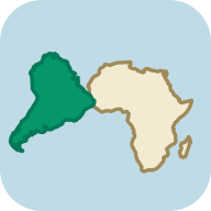
Why does South America fit against Africa?
The east coast of South America and the west coast of Africa fit together like puzzle pieces because the two continents were once one landmass in Gondwana. Only the opening Atlantic pushed them apart. On the continental drift map, move the age slider and watch the ocean form between them.
South America: rivers and lakes from our atlas
Rivers
- RiverAmazon6,400 km · basin 7,050,000 km²
- RiverParaná4,880 km · basin 2,800,000 km²
- RiverOrinoco2,740 km · basin 1,039,000 km²
Lakes
Countries and territories: South America in our catalogue (13)
Explore South America further
World ExplorerTravel from country to country: answer a question about each one to take it, then walk on to its neighbours.
The other continents
South America: frequently asked questions
How many times larger is Africa than South America?
About 1.7 times. Africa covers about 30.4 million km² and South America about 17.8 million km², so it would fit inside Africa with room to spare larger than all of Canada.
Which is the largest country in South America?
Brazil, at 8.51 million km². That is about 48% of the continent. Argentina is second (2.80 million km²).
How many countries are there in South America?
South America has 12 UN Member States. Our catalogue lists 13 entries for it, because it also shows the Falkland Islands (a British overseas territory claimed by Argentina). French Guiana has no entry of its own, because it is a region of France.
What is the highest mountain in South America?
Aconcagua, 6,961 m, in Argentina. It is the highest mountain outside Asia.
How big is the Amazon basin?
About 7.05 million km², around 40% of South America. The river is 6,400 km long.
Sources and definitions: Country areas: UN Demographic Yearbook 2024. Population: World Bank, 2025. Heights and depths: the measurements and lists named in the text (among them the joint Nepal and China survey of 2020, the National Park Service, Britannica). Antarctic ice sheet: Australian Antarctic Division. Antarctic Treaty: Secretariat of the Antarctic Treaty. Territorial claims and people at the stations: Australian Antarctic Division. UN Member States: United Nations (UN News, 2011). Cold record: WMO. Outlines: Natural Earth, public domain. Data methodology.