
How big was the Inca Empire?
At its peak in 1532, the Inca Empire covered about 2.03 million km², measured on the outline from the Cliopatria database. That is 6.5 times the area of present-day Poland and almost as much as Greenland, yet on a Mercator map Greenland looks 15.4 times bigger than the empire.
The empire's extent from 1450 to 1540
Move the year slider to see how the extent changed. Switch the projection to compare the empire with the rest of the world on a flat map and on the globe.
1532 2.03 million km², the largest extent
The empire also reached southern parts of present-day Colombia. This approximate outline leaves out that northern edge.
- Inca Empire
- Brown lines: present-day borders
Boundaries: Cliopatria (Seshat Global History Databank), licensed CC BY 4.0, modified: fitted to the coastline and simplified. Coastline and present-day borders: Natural Earth. Historical extents are approximate. Cliopatria · CC BY 4.0
Mercator versus true scale
The Mercator projection enlarges regions more the farther they lie from the equator. Both maps below use the explorer's scale and show the world from 60°S to 84°N. Red is the empire in 1532; purple is Greenland.
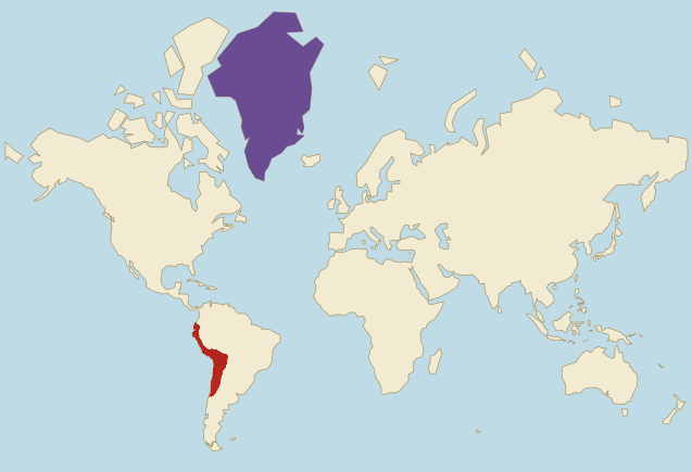
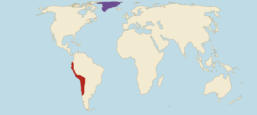
- Inca Empire (1532)
- Greenland
Borders: Cliopatria (Seshat Global History Databank), licensed CC BY 4.0, modified. Land: Natural Earth.
- On Mercator, Greenland looks 15.4 times bigger than the empire. In reality the empire had 94% of Greenland's area, so the two were almost equal.
- On Mercator, the empire looks only 2.8 times bigger than Poland. In reality it was 6.5 times bigger, because Poland lies much farther from the equator and grows more on this map.
- Mercator does not even treat the empire evenly. The part within present-day Chile grows on this map 1.3 times on average compared with land on the equator, while the part in Ecuador, right on the equator, hardly grows at all.
Estimate first, then check
At its peak, was the Inca Empire bigger than Greenland?
The empire next to today's countries
The empire's area in 1532 compared with selected countries, using the site's verified figures. The second line shows how the same comparison looks on a Mercator map.
- MexicoArea: 1.96 million km²The empire was about the same size.On Mercator it looks about the same size.
- PeruArea: 1.29 million km²The empire was 1.6 times larger.On Mercator it looks 1.7 times larger.
- BrazilArea: 8.51 million km²The empire had 24% of this area.On Mercator it looks like 26% of this area.
- PolandArea: 310,000 km²The empire was 6.5 times larger.On Mercator it looks 2.8 times larger.
- ItalyArea: 300,000 km²The empire was 6.7 times larger.On Mercator it looks 4.1 times larger.
- United KingdomArea: 240,000 km²The empire was 8.3 times larger.On Mercator it looks 3.3 times larger.
Present-day countries within the outline of 1532
We measure on the drawn outline and the country shapes the site uses. A country counts as partly inside when at least 5,000 km² of its territory lies within the outline. No present-day country lies wholly inside (the threshold is 95% of its area), because the empire held the Andes and the coast, not the Amazon lowlands. The historical extent also included southern parts of Colombia, which this outline does not show.
How the empire grew and fell
Five versions of the border from the Cliopatria database. From 1450 to 1532 the extent grew about 13 times.
1450
160,000 km² · 8% of the largest extent
Under Pachacuti, who defeated the Chancas around 1438 and took power in Cusco, the Incas brought the neighbouring valleys under their rule. The outline covers the area around Cusco, the former Chanca lands with Andahuaylas, and Ayacucho and Huancayo in the central Andes. The coast with present-day Lima and Lake Titicaca are still outside it.
1475
440,000 km² · 22% of the largest extent
Pachacuti and his son Topa Inca Yupanqui led the empire north along the Andes as far as Quito in present-day Ecuador, and down to the coast near present-day Lima. Cliopatria still draws the Chimú state on the northern coast, with its capital Chan Chan next to present-day Trujillo, as separate, although the Incas conquered it around 1470.
1482
520,000 km² · 26% of the largest extent
The outline now includes the former Chimú state, the northern coast of present-day Peru with Trujillo and Piura. Topa Inca Yupanqui rules, sole ruler from 1471 until his death in 1493.
1532
2.03 million km² · the largest extent
The largest extent in this set, which Cliopatria draws from 1497 until the Spanish conquest. The outline reaches from Quito to the Maule River in central Chile and includes Lake Titicaca, the highlands of present-day Bolivia and western Argentina from Salta to Mendoza. In 1532, after a civil war between Huayna Capac's sons Huáscar and Atahualpa, Francisco Pizarro captured the victorious Atahualpa at Cajamarca. A year later the Spanish took Cusco.
1540
4,900 km² · <1% of the largest extent
After the failed uprising of 1536 and 1537, when his forces besieged Cusco, Manco Inca withdrew into the mountains of Vilcabamba. The outline now covers only that small state, where the last Inca rulers held out until 1572, when the Spanish executed Túpac Amaru.
Why the border is approximate
The Incas called their state Tawantinsuyu, "the four parts together". They ruled mainly the Andes and the Pacific coast, and on the edge of the Amazon they held only scattered forts and roads. The Cliopatria outline reaches into the lowlands in places, around present-day Santa Cruz in Bolivia for example, which is why other maps draw the empire narrower and published estimates of its area differ from one another.
Cliopatria records the conquests in large steps. It shows Chile, the Bolivian highlands and western Argentina only from 1497, although historians link these conquests mainly to the reign of Topa Inca Yupanqui, who died in 1493. The database draws the Chimú state separately until 1481, although the Incas conquered it around 1470.
The figures on this page describe the drawn outline. We clipped it to the Natural Earth coastline and extended it to the coast where it stopped short. The source polygon reached out over the Pacific in places, so the peak area shrank by 3.3%. Lake Titicaca counts as part of the territory, as Cliopatria draws it.
Frequently asked questions
At its peak in 1532, the outline from the Cliopatria database covers about 2.03 million km². That is 6.5 times the area of Poland and roughly the size of present-day Mexico.
In the Cliopatria database the largest extent falls between 1497 and 1533, the reign of Huayna Capac and the civil war between his sons, up to the Spanish conquest. The outline then reaches from present-day Ecuador to central Chile.
No, but it came close. In 1532 the empire had 94% of Greenland's area. On a Mercator map, though, Greenland looks 15.4 times bigger, because it lies far to the north while the empire lay close to the equator.
The empire covered parts of present-day Peru, Bolivia, Ecuador, Chile, Argentina and Colombia. None of these countries lay wholly within it. The approximate outline used on this page leaves out the Colombian edge, which is why the list measured on the map includes five countries.
The Mercator projection enlarges regions more the farther they lie from the equator. The empire lay close to the equator, so on this map it is on average only 1.1 times larger than a region of the same size right on the equator. Europe and Greenland grow far more, which is why on Mercator the empire looks only 2.8 times bigger than Poland, even though it was 6.5 times bigger.
Less than a hundred years. Pachacuti took power in Cusco around 1438; in 1532 the Spanish captured Atahualpa, and a year later they took Cusco. The last Inca rulers held out in the mountains of Vilcabamba until 1572.
Sources and method
- Borders: Cliopatria (Seshat Global History Databank), licensed CC BY 4.0, modified: fitted to the coastline and simplified. Cliopatria (GitHub) · CC BY 4.0
- Coastline and present-day borders: Natural Earth, public domain. Natural Earth
- We measure the empire's area on the globe from the drawn outline. The apparent ratios on the maps use the same method as the projection comparator: the mean local area scale on a 0.5° grid. Projection comparator
- Present-day country areas come from the site's verified data. Data methodology
- The historical extent across six present-day countries, including Colombia: National Museum of the American Indian, Smithsonian Institution. Smithsonian: the Inka Empire